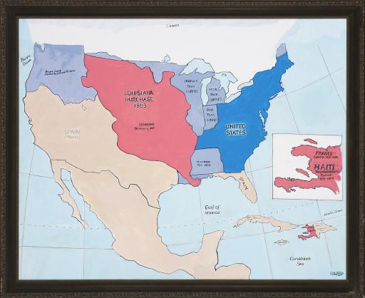
Map of Haitia-Louisiana Migrations, Ulrick Jean-Pierre

Artwork Overview

Map of Haitia-Louisiana Migrations, 2018
Where object was made: United States
Material/technique: oil; canvas
Credit line: Courtesy of the artist
Accession number: EL2018.101
Not on display

If you wish to reproduce this image, please submit an image request

Images

Label texts

The Ties that Bind: Haiti, the United States, and the Art of Ulrick Jean-Pierre in Comparative Perspective
This map illustrates the geopolitical boundaries of North America in the early 19th century and highlights Haiti’s location on the western half of the island of Hispaniola. It also shows the extent of the Louisiana Territory, a massive section of land previously owned by the French that Napoleon was forced to sell to President Thomas Jefferson to bear the cost of France’s loss of Haiti after the Haitian Revolution. By shading both Haiti and the Louisiana Territory red, Jean-Pierre demonstrates not only the historical link between Haiti and the American heartland, but also alludes to the significant migration of people from Haiti to this region in the early 1800s.
The Ties that Bind: Haiti, the United States, and the Art of Ulrick Jean-Pierre in Comparative Perspective
This map illustrates the geopolitical boundaries of North America in the early 19th century and highlights Haiti’s location on the western half of the island of Hispaniola. It also shows the extent of the Louisiana Territory, a massive section of land previously owned by the French that Napoleon was forced to sell to President Thomas Johnson to bear the cost of France’s loss of Haiti after the Haitian Revolution. By shading both Haiti and the Louisiana Territory red, Jean-Pierre demonstrates not only the historical link between Haiti and the American heartland, but also alludes to the significant migration of people from Haiti to this region in the early 1800s.

Exhibitions