Displaced Peoples 2, Chris Pappan

Artwork Overview

Chris Pappan, artist
Cultural affiliations: Osage, Kaw, Cheyenne River Lakota Sioux
born 1971
Displaced Peoples 2, 2011
Where object was made: New Mexico, United States
Material/technique: wood panel; acrylic
Dimensions:
Canvas/Support (Height x Width x Depth): 110 x 82 cm
Canvas/Support (Height x Width x Depth): 43 5/16 x 32 5/16 in
Frame Dimensions (Height x Width x Depth): 46 1/4 x 35 1/4 x 1 in
Credit line: Museum purchase: Peter T. Bohan Art Acquisition Fund
Accession number: 2012.0010
On display: Loo Gallery

If you wish to reproduce this image, please submit an image request
Images

Label texts

Collection Cards: Places

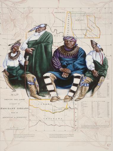
An antique map of Native American territories makes up the background of this painting. Because the Earth is round like a ball, it is difficult to create two-dimensional maps that are not misshapen. The distorted people in the center of the artwork communicate this idea. The people depicted in this work also convey how human-made borders on maps can affect peoples’ lives. Maps like this one determined where Native Americans could and could not live, altering their lives forever.

How would you feel if someone created a map that told you where you could and could not live?

How would you feel if someone made a map that controlled where you could and could not travel?

Displacement

These maps of present-day Kansas and Oklahoma reference the removal and relocation events of the Central Plains in what became Indian Territory west of Arkansas and Missouri. The figures are depicted in a distorted fishbowl perspective of a globe, drawing connections between forced geographic displacement and its inevitable and harmful impacts on culture and identity worldwide. How does this work connect with ideas about land acknowledgement found in this gallery?

Exhibition Label:
"Passages: Persistent Visions of a Native Place," Sep-2011, Nancy Mahaney
This piece is the first in a series of paintings that reproduces historical antique maps of Indian territories focusing on removal and relocation events to the Central Plains in what became Indian Territory in present-day Kansas and Oklahoma. Distorted figures of people endemic to those areas are juxtaposed on the map to show the impact of how a simple little line on a map can devastate an entire populace. The figures are distorted because people have a distorted view of American Indians in their minds and we are also guilty of distorting that image as well.

Exhibitions

Nancy Mahaney, curator
2011–2012
SMA Interns 2014–2015, curator
Cassandra Mesick, curator
Supervisor, curator
2015–2016
D. Justin Richland, curator
Alaka Wali, curator
2016–2019
2022–2027
2022–2027